


Archaeological Features on Crinan Moss (Mòine Mhòr): Summary of Site Visit, 16–19 August 2010
Richard Lathe
Pieta Research, Edinburgh, UK, and State University of Pushchino, Russia
©2015 by Richard Lathe. All intellectual property rights reserved. This edition copyright ©2015 by The Heroic Age. Permissions granted for educational and personal purposes only.
Objectives
§1. Dunadd (Dun Add, formerly Duin Att/Dun At) was an early stronghold of the Dalriadic Scots. Lathe and Smith (2014) suggested that sea-levels in the area have fallen over the last millennia and that the fortification was first constructed on an island or promontory in Crinan Bay.
§2. A contrasting view has been put forward (Campbell, E.; personal communication) that the presence of many ancient and historic monuments on Crinan Moss cannot be excluded, and that therefore one must consider that the Moss may not have been extensively inundated into historic times.
§3. A site visit was therefore undertaken to investigate all such monuments and the light they could potentially cast on changes in sea-level in the vicinity. For the purposes of this survey all archaeological features at or within the 10 m contour surrounding the Moss were considered.
§4. Sixteen such monuments were identified by reference to current UK Ordnance Survey (OS) maps and the Canmore database maintained by the Royal Commission on the Ancient and Historical Monuments of Scotland (RCAHMS) (http://canmore.rcahms.gov.uk/). The locations of these monuments are shown on the map (following page) and the correspondence between the feature numbers shown on the map and the Canmore ID numbers is given in the table below.
| No. | Canmore ID | Type | Grid (NR) |
|---|---|---|---|
| 1 | 39174 | Caves | 7990 9380 |
| 2 | 39475 | Cist | 8109 9585 |
| 3 | 39476 | Cist(s) | 8136 9567 |
| 4 | 39564 | Fort | 8365 9356 |
| 5 | 39576 | Cairn (possible), cist | 8147 9487 |
| 6 | 39581 | Standing stone | 9396 9344 |
| 7 | 39583 | Standing stone(s) | 8483 9248 |
| 8 | 39584 | Standing stone(s) | 8470 9290 |
| 9 | 39592 | Standing stone | 8386 9361 |
| 10 | 39606 | Enclosure (possible) | 8113 9478 |
| 11 | 39607 | Standing stone(s) | 8083 9409 |
| 12 | 39608 | Cairn | 8090 9408 |
| 13 | 39609 | Structure(s) | 8142 9304 |
| 14 | 76387 | Cup-marked rock | 810 945 |
| 15 | 109413 | Long barrow | 8453 9338 |
| 16 | 154425 | Township | 8383 9364 |

Map of Monuments at Crinan Moss. Link for higher resolution.
Locations of Monuments
§5. The monuments within the confine of the 10 m contour fall into two clusters: 1, 11, 12, 14, 10, 5, 2, and 3 at the NW end of the Moss closest to the sea, and 4, 16, 9, 6, 15, 8, and 7 at the SE end of the Moss. Monument 13 was not investigated because it is likely to be the remains of a shooting butt of recent origin (Canmore website).
Cluster 1: NW
§6. Three features are above the 10 m contour (1, 10, 14) or immediately adjacent (2 and 5) and were therefore not investigated in detail.
Features 11 and 12
§7. Immediately to the E of these features, and about 300 m from the public road (B8025), is an area of raised ground (rising above the 10 m contour) with rocks and fissures indicative of exposure to wave action and suggestive of a former island, referred to here as island 1 (IS1; Figure 1). Extensive bracken coverage on the main outcrop prevented detailed survey.
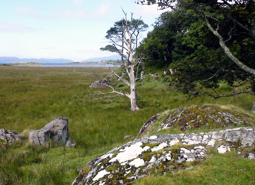
Figure 1
§8. From the top of IS1 (808 941) a grey standing stone can be seen, almost hidden in the moss, about 100 m due W of the most southerly highpoint of IS1. The ground at the location is a little higher and drier but is not markedly distinct from the surrounding flats.
§9. Three stones form three points of a rectangle (Figure 2). The highest stone stands approximately 1 m high above the surrounding moss, the other two stones stand approximately 0.5 m high. The three stones appear to be well set in the ground. From the higher stone the bearing to the closer short stone is 110o (L to R in the picture).
§10. Of the other adjoining stones mentioned in the Canmore database (0.2 m, 200 m ESE, 0.2 m, 20 m SE, or 150 ft SE) meticulous search revealed no trace and it appears likely they no longer protrude above the tussocks. Similarly, there was no trace of a cairn.
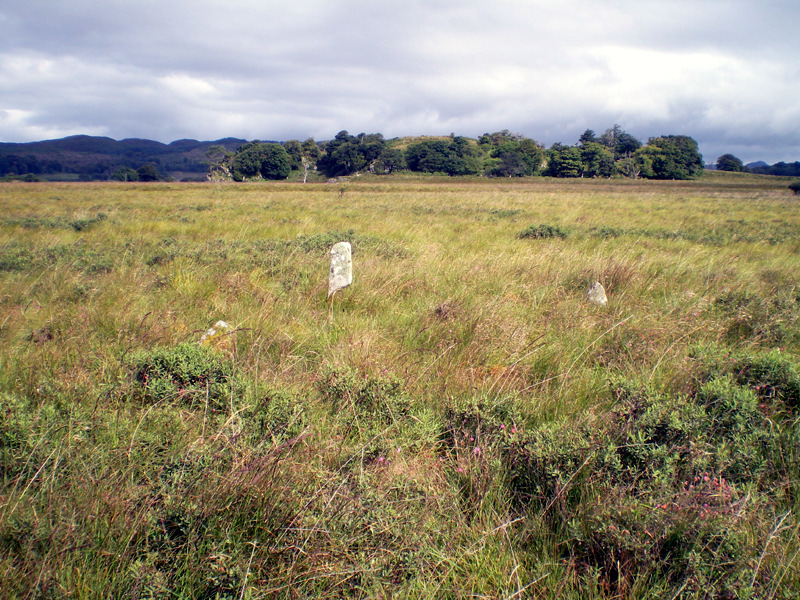
Figure 2
Features 10 and 14
§11. Proceeding from IS1 due N the land rises a little, in the order of 1 m, to a second island feature (termed IS2), higher than the first (visible in the distance on the photograph of the standing stones above) with evidence of water-exposed rocks. There is a sharp transition from bog to grass at the border of the outcrop. Both feature 10 (possible enclosure—"nothing significant seen," as reported in 1973) and 14 (cup-marked rock) are above the 10 contour on IS2 and were not inspected. IS2 is presently used for grazing cattle (Figure 3).
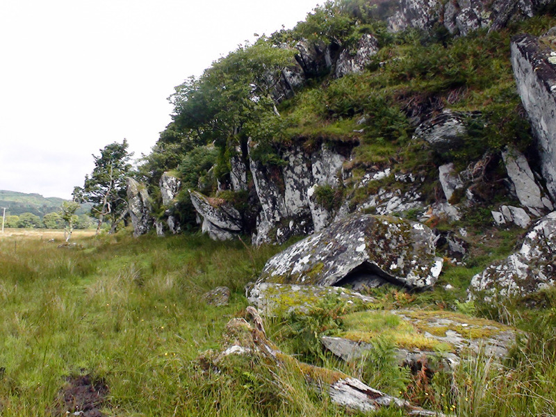
Figure 3
Feature 3.
§12. Proceeding N from IS2 the elevation of the moss rises gently, as confirmed by spot heights on the B8025 (from 4 m in the vicinity of the IS1 to 8 m 2 km NE). Feature 3 (cists) appears to be located in a small patch of mature woodland that is slightly raised above the surrounding land (Figure 4).
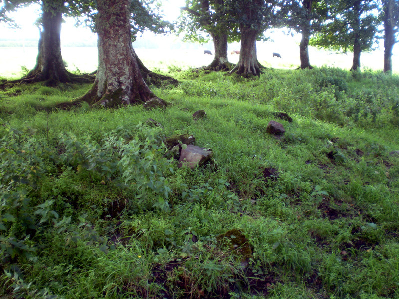
Figure 4
§13. The feature comprises piles of stones with unclear structure. A small stream traverses the wood through a narrow and deep cutting (2–3 m in depth). The putative cists are about 3 m above the level of the stream. The walls of the stream cutting are dark black silt. Around the woodland the land is dry pasture used for grazing cattle.
§14. There is some uncertainty because the description of the location (Canmore) is not precise ("75 yds S of the road;" "a little to the south of the public road"). It is possible that the cists referred to were not found; however, there is little if any change in elevation over the general area.
Cluster 2: SE
Features 4, 16, 9, 6
§15. Feature 16 (township) lies in the immediate vicinity of the Dun (Feature 4) is likely to encompass modern dwellings, and adjoins the 10 m contour. This was not investigated. The standing stone (Feature 9) is well-raised above the adjacent river and is set in a manicured lawn. The significance of this object was not evident given its small size and unknown date (Figure 5).
Figure 5
Feature 6
§16. SE from the Dun at a distance of 100 m is found a recumbent standing stone, 2 m wide and 3.5 m long, now packed at its south end with loose stones but which according to Canmore was still standing until recent times (upright in 1867; fallen by 1903). The two pictures (Figures 6 and 7) show the stone (i) from the S showing the Dun beyond and (ii) from the E. The stone is elevated above the angler's path along the river and is at a location that rises marginally from the surrounding land. As for Features 7 and 8, the land elevation drops towards the river W-E to a lower meadow.
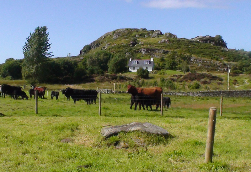
Figure 6
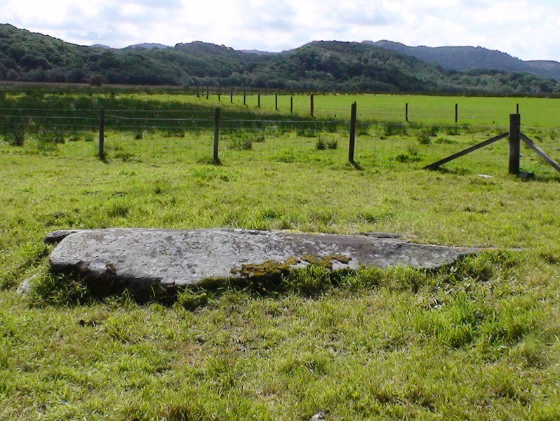
Figure 7
Feature 15
§17. This comprises a cursus seen from photography from the air and is not evident from ground level.
Features 7 and 8
§18. Proceeding from the public road (A816) at 850 923 a field is crossed to reach after about 300 m a pair of standing stones (Feature 7).
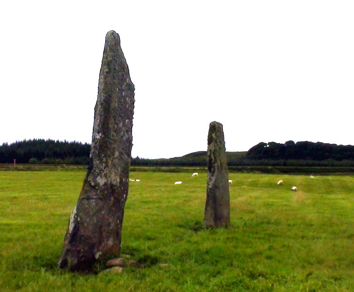
Figure 8
§19. The stones (Figure 8) are arranged approximately NW-SE, with the more southerly stone being approximately 4 m high, 1.5 m wide, and 0.5 m thick. The northerly stone is about 3 m high, 1 m wide, and 0.3 m thick. The stones are set in an area of flat dry grassland immediately adjacent to a gentle slope downwards (W to E, L to R in picture below) to another meadow adjoining the river (Figure 9).
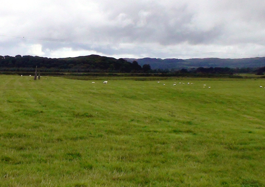
Figure 9
§20. About 200 m E from these stones a stream has cut through the top 2 m; the walls of the cutting are brick-red fine silt containing occasional rounded pebbles, often flat.
§21. Proceeding NW from Feature 7 another group of stones is found at a distance of 400 m (Feature 8). Two stones are now recumbent, the third stone is about 2 m in height (Figures 10 and 11). Again, the stones are set in dry level land that falls towards another area of lower land that adjoins the river (W to E, L to R in the picture). When last visited (1983) the most southerly stone (L) was still upright (Canmore).
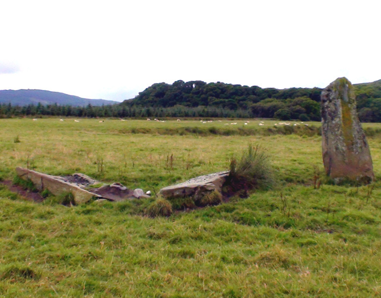
Figure 10
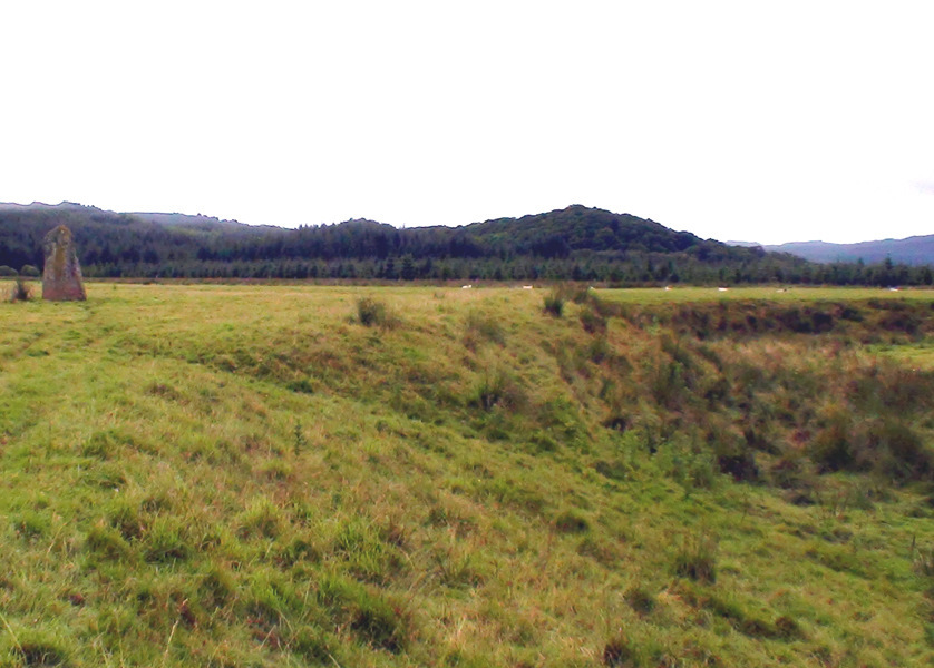
Figure 11
§22. It is not clear whether the groups of stones at Features 7 and 8 are at the same elevation or whether stones 8 are slightly lower than the group at 7. Both groups of stones overlook a drop of land height that probably represents a former river bank or shore line. This could also be true of 6.
General Observations
1. The 8 m OD Contour
§23. All the features discussed, with the exception of 11/12, lie at or above the ~8 m contour. The three standing stone features (6, 7, and 8) all appear to be located overlooking a former shoreline, although it is not clear whether they are at the same elevation. Feature 3 also adjoins the 8 m contour. Therefore, one can be fairly confident that, with the exception below, all monuments on Crinan Moss are at or above this elevation.
2. Status of Features 11/12
§24. The location and existence of these standing stones is at odds with the interpretation that the moss was a wide marine estuary into historic times. There are caveats. First, the labor involved in the construction of Feature 11 amounts to not more than an afternoon by a single individual (in contrast to the very substantial labor involved in constructing Features 6, 7, or 8). Second, the dating of these stones is not known, and it is likely that they are of recent origin because this is very low-lying land and will have been inundated into recent times, and is probably still inundated at times of exceptionally high tide—that the stones are still standing argues for a recent date.
3. Multiple Island Features
§25. In addition to the island features (IS1 and 2) close to the sea, and Dun Add itself (see Panorama 1 at the end of this document), it is of note that the adjacent outcrop at 843 932 would potentially have also been an island. The OS map has no name for this feature; here it is referred to as island 3 (IS3). The low-lying land between IS3 and Barr na Fhithich is dotted in the map.
4. The Isthmus between Dun Add and IS3
§26. The tract of land linking Dun Add to IS3 (Figure 12) is of central importance in adjudging when the Dun was last an island.
Figure 12
§27. Seen from the Dun (looking SE) the isthmus is at two levels (Figure 11), to the E (L of Figure 11) of a newly constructed farm track the land is dry grassland leading to Feature 6, whereas to the W (R of Figure 11) the land is boggy and possibly 0.5-1 m lower than the adjoining farmland. It is possible that the farmland area and road may have been infilled to raise their level in recent times. The same contrast is seen between the farmland and bog is when viewed from IS3 (Figure 13).
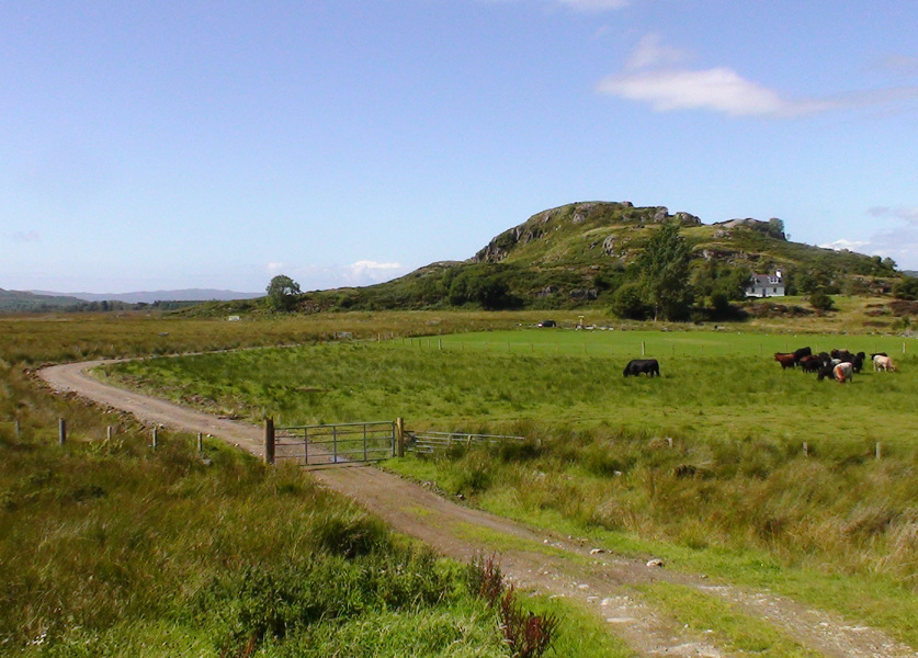
Figure 13
§28. Overall, the elevation of the isthmus is estimated to be at or marginally above the 8 m contour (see Panorama 1). It is not clear whether the elevation of the isthmus between IS3 and the next high ground (Barr an Fhithich) is higher or lower than that between IS3 and the Dun.
5. Multiple Land Levels and Former Shorelines Adjacent to the River Add
§29. On Panorama 1 it is clear that, to the NE of the Dun, there is a drop in elevation between the general area and a lower area of meadow adjoining the present day river. The extent of this drop is about 3 m or possibly a little more (arrowed in Figure 14 below, a panel from Panorama 1). At a more recent time the area occupied by the River Add was clearly much larger. It is possible that this former river bank (upper arrowed level) extends upstream to run adjacent to Features 6–8. The lower meadow in the Figure below therefore approximately represents the 4–5 m OD contour.
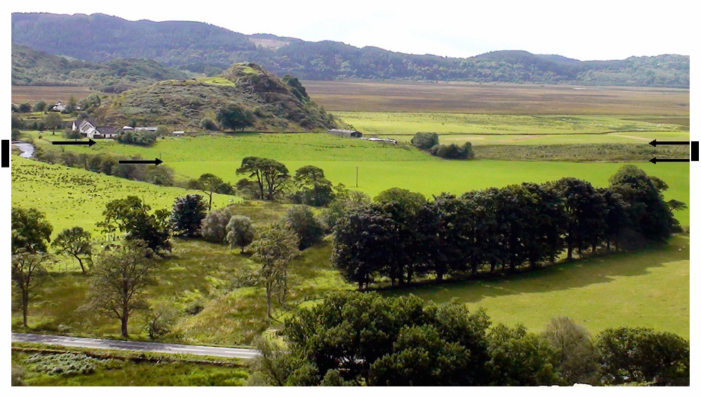
Figure 14
Conclusions
§30. Central observation: all the significant monuments listed are at or above the 8 m contour—and there appear to be no significant archaeological features on the flats of Crinan Moss. Two or three of the most relevant features appear to have been constructed to overlook a former shoreline or river bank.
§31. A second conclusion is that the isthmus between the Dun and IS3 is a little higher than the surrounding terrain, and is sited approximately at 8 m OD (by reference to the OS map 10 m contour)—whereas the present surface in the vicinity was previously estimated to lie at circa 6–7 m (Lathe and Smith 2014). Land levels on the other three sides of the Dun are somewhat lower, probably close to the estimated 6–7 m.
§32. This raises the possibility that, at time of construction of the standing stones (Features 6–8), the Dun was linked to IS3 by a causeway. However, possible infill of farmland E of the IS3-Dun track needs to be investigated. In addition, the relative elevation of the isthmus between IS3 and Barr an Fhithich versus IS3 and the Dun is not known, although the OS map shows the former as above 10 m OD and the latter below. The possibility that IS3 was also fortified deserves consideration.
§33. The lower level adjoining the river in Figure 14 is likely to recent erosion as a result of periodic flooding of the River Add.
§34. These conclusions are crucially dependent on the accuracy of OD measurements given on the current OS maps. Re-evaluation of when Dun Add was last surrounded by water could require:
- Accurate measurements of OD elevations for the different land levels in the vicinity of Dun Add (and investigate possible infill at the isthmus).
- Radiocarbon dating across the isthmus between the Dun and IS3—and, depending on accurate elevation data, possibly also between IS3 and Barr an Fhithich. Cores would need to be in the order of 4 m in depth.
- Sampling of the lower flats (4–5 m OD) close to the river could also assist interpretation.
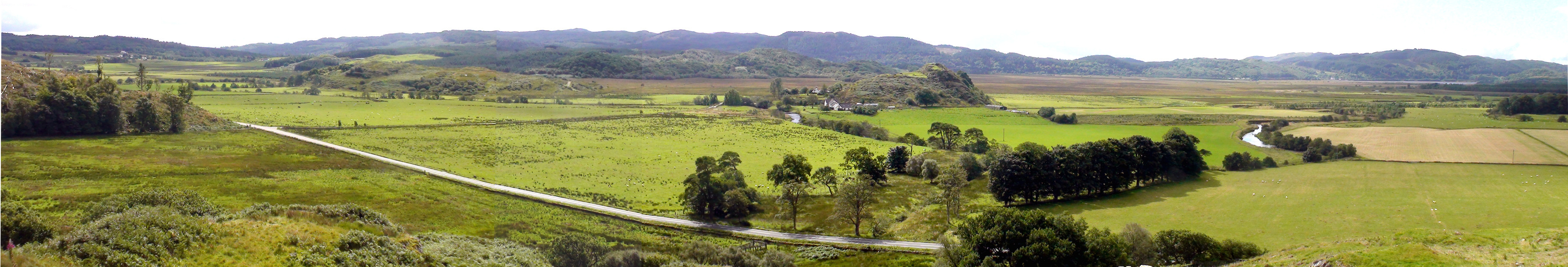
Panorama 1. Dun Add site looking SW from Barr na Crannaich (844 943)
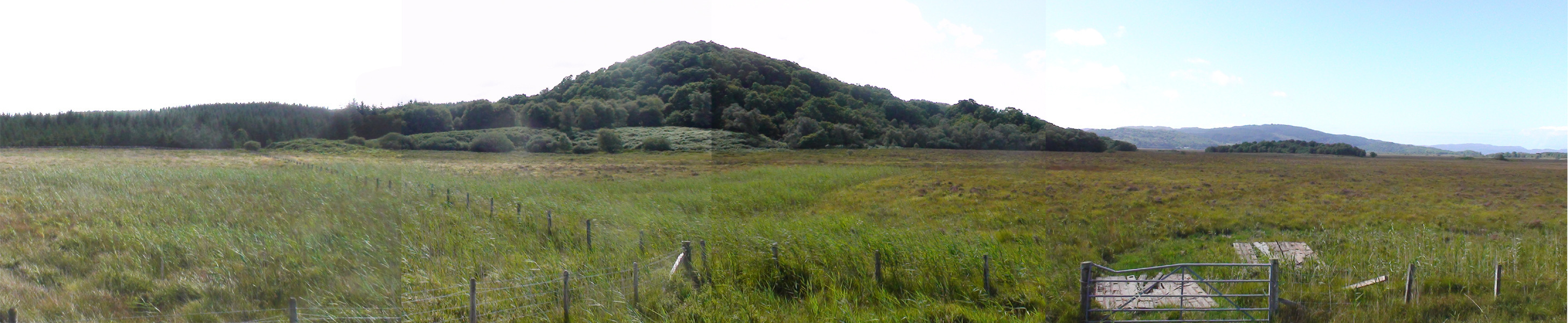
Panorama 2. From the SW point of IS3 (839 929) looking S towards Barr an Fhitich (center, 57 m in height).