
|
The Heroic AgeIssue 4Winter 2001 |
Abstract: The evidence for occupation at the Roman fort site of Cramond between the fourth and tenth centuries A.D. is assessed using a variety of sources of evidence including artefacts, place-names, documents and the location of later structures. It is argued that this evidence suggests both British and Anglo-Saxon occupation. Although its exact nature is unclear, a religious element is likely.This article was amended by the author on February 20, 2001.
Contents:
The nature of the Anglo-Saxon impact in southern Scotland has
traditionally been dominated by documentary sources and to a lesser
extent place-name studies. More recently archaeology has begun
to influence how we understand this phenomenon. Whilst much of
the impetus for this has come from recent excavations such as
Whithorn (Hill 1997),
Dunbar (Holdsworth 1993),
and the Mote of Mark (Laing
1973, 1975; Longley 1982), a considerable
amount of information can be gained from older excavations. Although
the evidence from older excavations is problematical it can be
of significance when critically reappraised.[1]
Until relatively recently Roman fort sites were generally excavated
in a manner unlikely to aid the understanding of post-Roman phases
of occupation. We are therefore forced to rely upon stray finds
of artefacts and other sources such as place-names, documentary
sources, and the location of later Medieval structures to attempt
to understand any post-Roman occupation of such sites.
 |
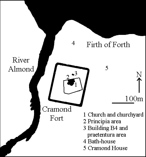 |
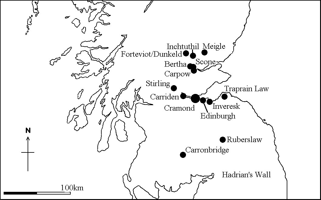
The Roman fort at Cramond, Lothian [NT 189768], on the south side
of the Firth of Forth next to the river Almond, was an important
military base during the Antonine occupation of Scotland (c. A.D.
140-190) and the early third century Severan campaigns. The fort
was probably garrisoned during the Severan occupation from A.D.
208 to 210, and is likely to have been evacuated in A.D. 211 or
212. Its importance did not end at this time, and there is a considerable
body of evidence for post-Severan activity at Cramond that probably
continued until the end of the first millennium A.D. The exact
nature of this occupation is unclear but can be partially reconstructed.
Occupation of the fort during the later third and fourth centuries
has long been recognised as a possibility (MacDonald
1918:214, 216). In the praetentura area of the fort
a stone building, designated B4, was constructed re-using red
sandstone ashlar from the Severan principia and sealed
a coin of Julia Domna (A.D. 196-211) (Rae
and Rae 1974:184-86). The exact date of construction is unclear,
but it probably belongs to the first half of the third century.
The building was crudely made of stone bonded with clay with a
floor consisting of a hard tread of stones, cobbles, and dried
mud. It appears to have possessed glass windows. The unskilled
nature of the construction and the crudity of its floor were interpreted
as suggesting that this structure did not indicate a further period
of Roman military occupation, but it was seen as sophisticated
enough that it could not be dismissed as squatter occupation.
Other post-Severan structural activity has been discovered at
the bath-house to the north of the fort, where furnaces were inserted
and there was some late third-century pottery (Frere
1977:368-70; Grew 1980:354).
This phase at the bathhouse is comparable to the activity at the
praetentura, as it also has crudely built stone walls bonded
with clay. The bathhouse was eventually deliberately dismantled,
suggesting that the site was still occupied after the bathhouse
went out of use. It is now thought that the evidence from the
bathhouse and praetentura may relate to a short phase of
small-scale Roman military occupation immediately postdating the
general abandonment of the fort in A.D. 211/212.
Both building B4 and the bathhouse produced late third-century
Roman pottery indicating continuing contacts with the Roman province
to the south. There is also a general scatter of pottery of this
date from other parts of the fort and the nearby vicus (Goodburn 1978:418; Rae and Rae 1974:217-18).[2]Such contacts are also
indicated by a number of Roman coins. The site has produced coins
of Geta (A.D. 211-12), Caracalla (A.D. 211-17), Tetricus II (A.D.
270-73/4), Probus (A.D. 280-81), Diocletian (A.D. 284-305), Galerius
(A.D. 305-11), Constantine I (A.D. 306-37) and Constantine II
(A.D. 337-61) (Bateson 1989:167;
Robertson 1983: table
2).[3]These coins are
all stray finds but do appear to indicate continued activity throughout
the third and first half of the fourth centuries.
Stray finds of post-Severan coins from Scotland are a problematical
source of evidence (Casey
1984; Robertson 1983:429-30).
The evidence from Traprain Law clearly shows that the Votadini
continued to have access to Roman coins throughout the third and
fourth centuries (Sekulla
1982), so there is no a priori reason to discount the
coins from Cramond. Casey suggests that coins from western mints,
particularly Trier and Lyons, are more likely to be genuine, but
this can not be taken as an absolute criteria (Casey
1984; see also Bateson
1989). Some of the coins from Cramond are of particular interest:
the coin of Tetricus came from the spoil heap associated with
the bathhouse excavations and was minted at Cologne; as it comes
from a western mint it may well be genuine (Robertson
1983:408). Much of the bathhouse was robbed to foundation
level in the seventeenth century and subsequently large quantities
of soil and associated debris were dumped on the site. Much of
this material may have come from some distance away, so that some
of the later third- and fourth-century artefacts may not be associated
with the bathhouse at all. Even if this is accepted, the material
must still have come from somewhere on the Roman fort or the civilian
settlement. Coins of Diocletian, Galerius, and Constantine I were
all found in close proximity during the digging of a garden at
15 Glebe Road and are described as having an "emphatic"
provenance (Robertson 1971:115-16),
although only the coin of Constantine, from Arles, is from a western
mint. This collection--which comes mainly from eastern mints,
does not include any Severan or earlier coins, and was found in
association with a later Byzantine coin (see Later
Artefacts below)--probably represents a modern loss.
Excavations in the 1970s uncovered some poorly preserved structural
remains indicating a short-lived immediately post-Severan phase
of activity on the site; they also produced some pottery indicating
post-Severan activity (pers. comm., Nicholas Holmes 1998). The
excavator interpreted this as indicating that there was some native
re-occupation of parts of the site and that Roman patrols probably
continued to visit the site throughout the third century, but
there was no evidence for activity after the late third century.
>From the patchy evidence that has been recovered, it seems that
activity continued at Cramond throughout the third century and
possibly into the first half of the fourth century. The nature
of this occupation is unclear and difficult to interpret, but
it indicates that Cramond was not completely abandoned during
the third and fourth centuries.
Although no structural remains of the Early Historic period (A.D.
400-1100) have been found at Cramond, a number of artefacts of
this period have been discovered. There is a bronze coin of the
Byzantine emperor Justinian (A.D. 527-65) (Robertson
1971:115-16), which was discovered in the same location as
some post-Severan coins discussed previously. Although most Byzantine
coins from the British Isles are dismissed as modern losses (Casey 1984:295), there
is evidence for trade between the eastern Mediterranean and western
Britain and Ireland c. A.D. 475-550 that penetrated as far north
as central Scotland (Alcock
and Alcock 1990; Fulford
1989). There is therefore no reason to automatically discount
the coin of Justinian from Cramond, although the coins that it
was discovered with suggest that it may well be a modern loss.
Another discovery was an eighth- or ninth-century enamelled bronze
circular mount with equal-armed cross decoration incorporating
millefiori and yellow champleve enamel discovered in the
churchyard at Cramond, which overlies the fort (Bourke
and Close-Brooks 1989:230-32).[4]
This was probably originally part of a larger composite Insular
object, probably ecclesiastical. A plain bronze finger ring discovered
at Cramond in 1870 whilst digging a grave near the church bears
an Anglo-Saxon runic inscription "[.]ewor[.]el[.]u."[5 ]The letters "wor"
are best interpreted as part of the Old English word worthe,
"made," and the rest of the inscription probably consisted
of one or two Anglo-Saxon personal names. Although it has been
suggested that this item is ninth century, it is not closely dateable
and the only thing that can be said with certainty is that it
probably dates to between the second half of the seventh century
and the tenth century (Laing
1973:18; Page 1973:36).
A blue glass bead found near Cramond House (PSAS
1970: no. 10) is not closely dateable, but such items are
typical of Early Historic Celtic sites.
These various stray finds from in and around the fort suggest
that it continued to be a focus for activity until at least the
eighth or ninth centuries. The enamelled mount in particular suggests
a site of some wealth and importance. The lack of structural evidence
hinders any interpretation. It is unclear from the archaeological
evidence if the site was continuously occupied and whether it
was a secular or religious site.
The place name Cramond is not recorded prior to the twelfth and
thirteenth centuries, when it is found in a number of forms such
as Caramonde/Caramonth (A.D. 1178-79), Karramunt (A.D. 1166-1214),
and Karamunde (A.D. 1293) (Nicolaisen
1976:162; Watson 1926:369).
The name contains the distinctive Brythonic or P-Celtic element
cair/caer, which means "fort," plus the river
name Amon, whose exact linguistic roots are unknown (Nicolaisen
1976:160-62, 178). Cramond therefore means "fort on the
river Almond," and the name must have originated prior to
the conquest of this area by Anglo-Saxon Northumbria in the middle
of the seventh century.
The earliest part of Cramond parish church is the fifteenth century
tower, although parts of the building incorporate fourteenth century
masonry (RCAHMS 1929:27-28,
no. 37). It is located over the praetenturna of the Roman
fort, as are a number of other parish churches in Scotland including
Carpow and Inveresk (Smith
1996:24). This might be dismissed as coincidence, but as the
praetenturna was a focus for post-Severan activity and
the churchyard produced an Early Historic enamelled mount, this
suggests that the administrative centre of the Roman fort retained
some form of administrative or religious importance during the
Late Roman and Early Historic periods.
There are a number of possible documentary references to Cramond.
Bede (EH I.8; Colgrave and
Mynors 1991:40-41) refers to a site known as Urbs Giudi
in the early eighth century, and the same site is referred to
as Iudeu in the tenth century Historia Brittonium attributed
to Nennius. Historia Brittonium describes events in the
650s, when king Oswy of Northumbria was defeated by an alliance
of Penda of Mercia and some British kings at the urbem,
"city," of Iudeu and forced to hand over the Atbret
Iudeu, "treasure of Iudeu" (Morris
1980:38, 79). There is also a reference to the merin iodeo,
"sea of Iodeo" or Firth of Forth, in the Gododdin
poem (Jackson 1969:108;
Jarman 1988: line 944),
and Iodeo is probably the same as Iudeu. Guidi/Iudeu has sometimes
been equated with Cramond (Hunter-Blair 1947:27-28; Rutherford
1976:443) but opinion now generally favours Stirling instead (Alcock 1981:175-76; Jackson 1981; Jarman
1988:147, n. 944). There are two important pieces of evidence
against the identification of Guidi/Iudeu with Cramond. Firstly,
as it possessed a significant Roman past, Bede would probably
have termed it a civitas rather than an urbs (Campbell 1979). Secondly,
as the defences had been slighted and the ditches filled, the
site would not have been easily defensible. It is therefore unlikely
that Oswy would have retreated there when pursued by his enemies.
Another documentarily attested site is Rathinveramon, where two
kings died. Domnall, son of Alpin, rex Pictorum-king of
Picts-was killed in A.D. 862; and Constantine, son of Culen, ri
Alban-king of Scotland-was slain by Kenneth, son of Malcolm,
in A.D. 995.[6] The
deaths of two different kings in the ninth and tenth centuries
suggest that this was an important site. The first element in
the name Rathinveramon, which means "fort at the mouth of
the river Almond," is the Goidelic or Q-Celtic element rath,
which means "fort." Rath is an uncommon place-name
element for Scotland and refers to a site with a bank and ditch.
O. G. S. Crawford (1949:60)
believed that rath indicated a Roman fort and equated Rathinveramon
with the Roman fort of Bertha in Tayside, and this has generally
been accepted.[7] There
are, however, two river Almonds in Scotland: one in Tayside, beside
which Bertha is located; and one in Lothian, which flows past
Cramond. It is therefore conceivable that Rathinveramon is Cramond
rather than Bertha, a suggestion that has been made previously
(A. Anderson 1922, 1:518).
Rathinveramon is in fact the Goidelic equivalent of the Brythonic
name Caramonde. It is conceivable that the Scottish Goidelic-speaking
incomers adapted and gaelicised the existing Brythonic place-name.
The evidence for activity at Cramond at this time, in the form
of the eighth- or ninth-century enamelled mount and possibly the
ring with runic inscription (see Later
Artefacts above), supports this suggestion. In contrast there
is no evidence for any post-Antonine activity at Bertha (Adamson
and Gallagher 1986:203; Callander
1919:145-52).
The problem is that the documentary sources that mention Rathinveramon
were generally written down several centuries after the events
they describe. This allowed plenty of opportunity for confusion
to arise concerning which of the two rivers Almond Rathinveramon
was sited beside. Such confusion is best exemplified by the fourteenth-century
Scottish historian John of Fordun, who places the events of A.D.
862 in Tayside (IV.15) and those of A.D. 995 in Lothian (IV.34);
this was repeated by the twentieth-century historian Alan Orr
Anderson (1922, 1:291
n. 5, 518 n. 7; 1922,
2:782) when he quotes Fordun. The source with the best claim to
be contemporary is the Annals of Ulster, which do not state where
Domnall and Constantine were killed (MacAirt
and MacNiocaill 1983:318-19, 424-25). In contrast the sources
that seem to provide the most geographical detail are those like
the Prophecy of Brechan, which was not composed until the
1160s and whose reliability is open to question. The river Almond
in Tayside is located in an area that was an important focus of
Early Medieval royal activity with sites such as Scone, Forteviot,
Meigle, and Dunkeld, which encouraged early authors to place Rathinveramon
on the Almond in Tayside, perhaps erroneously. The documentary
sources do not allow an unequivocal decision between the rivers
in Lothian and Tayside, so it is at least possible that Rathinveramon
should be equated with Cramond rather than Bertha.
Edinburgh--Oppidum Eden--and therefore presumably Cramond,
was under Northumbrian control from the mid-seventh century until
the reign of the Scottish king Indulf (A.D. 954-62), when it passed
into Scottish hands apparently without a battle (A.
Anderson 1922, 1:468). When Constantine was killed at Rathinveramon
in A.D. 995, Cramond was under Scottish control and his presence
there is clearly possible. In A.D. 862, when Domnall was killed,
Cramond was still under Northumbrian control. The frontier between
Northumbria and Scotland was, however, probably relatively close
to Cramond and the Scottish kings were closely interested in this
area. Domnall's presence at Cramond in A.D. 862 is therefore quite
plausible.
The exact territorial boundaries of the Votadini are problematical,
the best source being Ptolemy's Geography, but other Roman
forts that the Votadini could have occupied in their heartland
along the southern side of the Firth of Forth were Carriden and
Inveresk. Carriden has not produced any evidence of post-Antonine
occupation during the Roman period, and the next clearly attested
occupation is during the thirteenth or fourteenth century (Bailey 1997). There is
a post-Roman phase consisting of a gully, drain, and post-hole,
which can not be precisely dated; it occurs some considerable
time after the Roman abandonment but prior to the thirteenth-
or fourteenth-century occupation (Bailey
1997:591). This evidence is extremely difficult to interpret
and only further work will elucidate its nature and precise date.
Excavations on both the fort and the vicus at Inveresk
indicate that it was not occupied during the Severan campaigns.[8] In fact there is no
evidence for occupation between the Antonine occupation and the
thirteenth or fourteenth century. Two coins of Gallienus (A.D.
260-68) and Constans (A.D. 341-46) are reported to have been found
at Inveresk (Robertson 1983:408)
but are not mentioned in the excavation report (Thomas
1988:171, fiche 2 A.12-B.1) and must be assumed to be erroneous.
The place-names of Carriden and Inveresk do not retain any elements
that preserve the memory of the presence of a Roman fort. The
fort of Carriden at the eastern terminus of the Antonine Wall,
which also falls within Votadinian territory, might appear to
be derived from Caer Eidyn, but this is problematical. Kenneth
Jackson argued that the early forms of the name such as Karreden
and Karedene can not be derived from this source but David Dumville
has challenged this (Dumville
1994). Even if Dumville is correct his argument suggests that
the name Carriden may be relatively late as he suggests that this
fort was originally named 'End of the Wall' [Penguaul, Cenail,
Peneltun] a topographical descriptive term later applied to
Kinneil and not necessarily indicating any occupation. The third
fort within Votadinian territory was Inveresk. This name contains
the Gaelic element inbhear, "in-bring", denoting
the junction or confluence of a river (Watson
1926:148), and must therefore post-date the Scottish take-over
of the area in the tenth century; in any case it makes no reference
to the presence of the Roman fort.
There is, however, some evidence that the site of Inveresk still
retained some importance. The location of the Medieval church
at Inveresk (see The Medieval Church
above) is suggestive, as are documentary sources which show that
it may have been the "centre of a territorial arrangement"
(Proudfoot and Aliaga-Kelly
1997:40-42). The evidence suggests that Carriden's position
at the end of the Antonine Wall was no longer of strategic importance,
but that Inveresk's position at the end of Dere Street may still
have been significant, although the site itself was probably not
occupied. The continued occupation at Cramond suggests that links
by sea may have been of greater importance than land-based links.
The archaeological, place-name, and documentary evidence suggests
that Cramond was an important site in the post-Severan period,
although its exact nature is unclear. In general Roman forts do
not seem to have been particularly favoured as locations for native
settlements in Scotland, although the evidence is probably not
as negative as suggested by Dark (1992:111,
n. 7), who focused solely on the fifth and sixth centuries. Apart
from Cramond there is evidence for a native fort at Inchtuthil,
Grampian, which re-used Roman masonry (Abercromby
et al. 1902). Perhaps less significant are a ninth- or tenth-century
silver-gilt penannular brooch, iron sickle, and sword found at
Carronbridge, Dumfries and Galloway, as their location at a Roman
fort has been described as "almost certainly coincidental"
(Owen and Welander 1995).
The other Roman fort apart from Cramond with substantial evidence
of Severan occupation is Carpow. While it lacks archaeological
evidence for occupation after the early third century (Birley
1963; Wright 1974),
it is mentioned in an early documentary source as Ceirfuill. The
source refers to a lapidem juxta Ceirfull, "stone
beside Ceirfuill" (Chadwick
1949:9-10), which may relate to a rather later fragment of
a cross-slab from Carpow House (Cessford
1996). Although this does not demonstrate that Carpow was
occupied, it indicates its continuing importance as a focal point
in the landscape. The evidence from Ruberslaw, Borders (Alcock
1979:134; Curle 1905),
is rather different, as the re-use of Roman masonry here involves
a hilltop site and the stone probably came from a signal station
tower rather than a fort.
Most known high-status sites in Scotland of the post-Roman period
are small- to medium-sized hillforts, whereas Roman forts, which
were larger, were probably too large for the requirements of the
period. They were also not located in naturally strong defensive
sites. There are, however, a number of important undefended sites
of this period, the most notable being Forteviot, Tayside (Alcock and Alcock 1992:218-41).
The continued activity at Cramond and other Roman forts may be
of a similar nature to Forteviot. Roman forts were located at
nodal communication points on the Roman road network, which probably
continued in use during the early Medieval period, and in the
case of Cramond the site was also well situated with regard to
communications by sea. Such forts also acted as quarries of raw
materials, notably for stone but also nails, glass, coins, and
other artefacts that were re-used during the early medieval period
in Scotland. Their history and a lingering sense of romanitas
may also have meant that controlling Roman fort sites provided
a source of authority and legitimacy to native dynasties.
Dark (1992; see also
Snyder 1996:47-48) has
suggested that the evidence of fifth- and sixth-century refurbishment
of defences, timber halls, inscribed tombstones, and Germanic
artefacts at forts on Hadrian's Wall indicates that they were
reused as part of a still-functioning military frontier with high-status
British occupation and the use of Germanic mercenaries. Whilst
there are certain similarities between the sub-Roman evidence
from Hadrian's Wall and that from Cramond, Dark's model appears
unsuitable for Cramond. There are no indications that the defences
at Cramond were still functional after the Severan period or that
there was a military presence at the site, so a martial interpretation
is difficult to substantiate. The enamelled bronze circular mount
and the location of Cramond parish church both suggest that there
was a religious component to the occupation at Cramond. The most
likely scenario is that ownership of the fort at Cramond passed
into the hands of the native dynasty of the Votadini after its
abandonment by Roman forces. There is no evidence that occupation
of the site was continuous and what the discoveries may instead
reflect is a continuity of royal ownership. Cramond was probably
controlled by a succession of royal owners in a manner similar
to that suggested for some Roman forts in England, where churches
occur from the seventh century onward (Bidwell
1997:108-9). The site continued in use after the Anglo-Saxon
take-over of the region in the early seventh century and may have
remained in use throughout the Anglo-Saxon occupation until the
tenth century. It is even possible that the Scots subsequently
occupied it.
The evidential basis for assessing the Early Historic occupation
at Cramond is fragmentary and open to a range of interpretations.
Nevertheless, given the focus upon substantial Roman structures
during previous excavations at the site combined with the frequently
insubstantial nature of building remains and the general lack
of dateable artefacts during the Early Historic period in Scotland,
the body of evidence that does survive is perhaps as much as might
reasonably be anticipated. Cramond appears to be a potentially
important site for understanding the complex interactions and
transitions between different political and ethnic groups in Northern
Britain during the second half of the first millennium A.D. If
its identification with Rathinveramon is correct, it is a site
where events of considerable historical significance took place.
Recent work on Hadrian's Wall has shown the potential for careful
excavation of Roman fort sites to uncover the less obvious evidence
for later periods of occupation and it is to be hoped that this
will eventually be repeated at Cramond.
|
|
|
|
|
|
|
|