

Time, Travel and Political Communities: Transportation and Travel Routes in Sixth- and Seventh-century Northumbria
Lemont Dobson
University of York
©2005 by Lemont Dobson. All rights reserved. This edition copyright ©2005 by The Heroic Age. All rights reserved.
Abstract: History informs us that the political relationships members of the Northumbrian elite sought to cultivate during the sixth to the seventh centuries tended to be situated around the eastern coastline of England rather than among their seemingly contiguous inland neighbors. It has been suggested that this would seem to indicate a preference for maritime travel. However, questions of navigability of waterways and ship technology are paramount. This paper seeks to combine a desktop survey of the northeast coast of Britain and its attendant inland waterways with an overview of Anglo-Saxon ship technology to compare the estimated travel times by the various routes available, i.e., land and sea, in order to place the politico-religious relationships formed by the Northumbrian elite during the sixth and seventh centuries into a geographical context.
Article Navigation
Some Problems to be Solved: History, Geography, and Archaeology
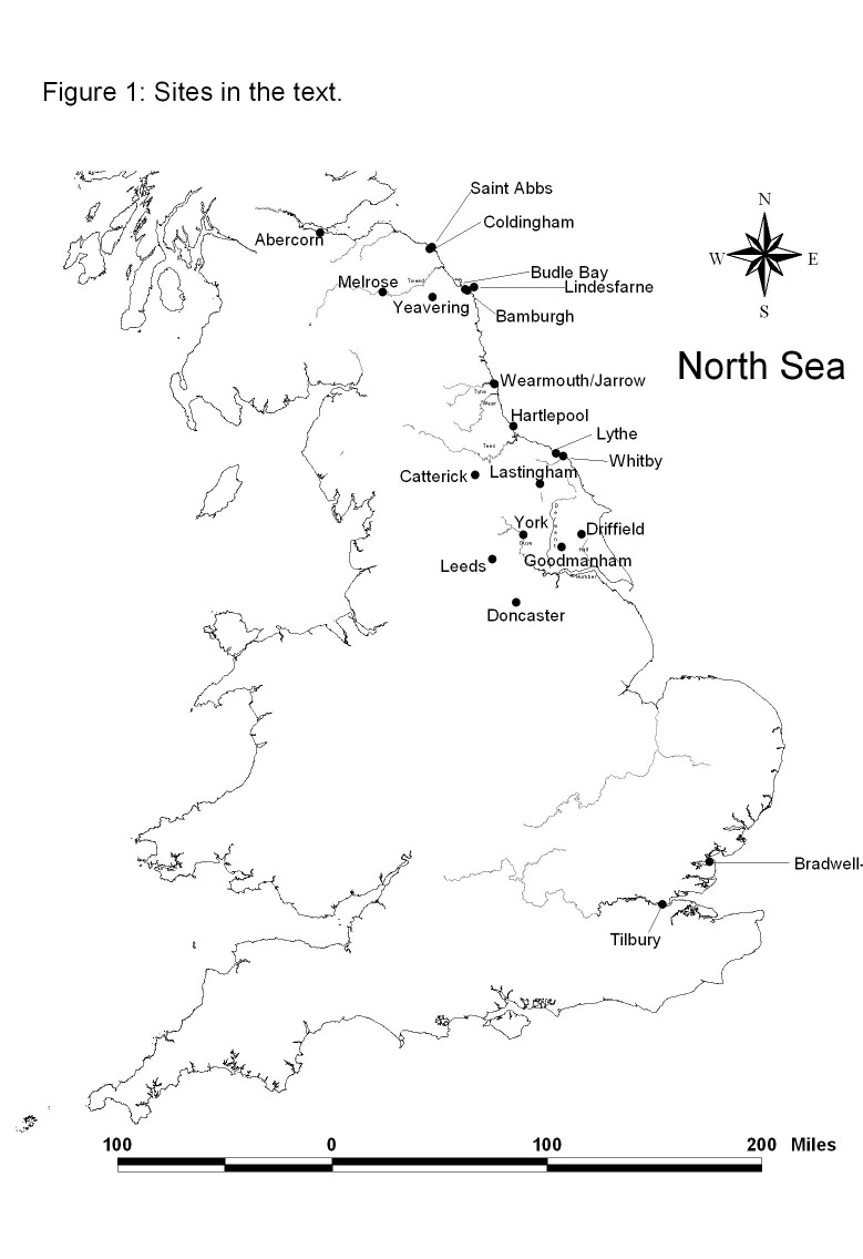
§1. The focus of this paper is the role that transportation routes and technology played in structuring the developing political communities in northeast England during the sixth and centuries, particularly the Anglo-Saxon kingdom of Northumbria (Fig. 1). The paper aims to combine an analysis of political actors in the region during the middle decades of the seventh century with a brief overview of recent research on the period in historical geography and archaeology as a means of interpreting the emerging political communities at the time. Towards this, three interrelated topics are discussed. First, the political landscape of the region during the sixth and seventh century is examined to provide a background for the analysis. Second, the physical landscape of the region is examined to determine which modes of travel were most advantageous. Finally, the question of Anglo-Saxons maritime technology is discussed.
The Political Landscape
§2. During the sixth, seventh, and eighth centuries the socio-political situation in the northeast of England is perhaps best described as a complicated negotiation of kinship. The emergence of an Anglo-Saxon elite in the late fifth and sixth centuries is followed by a debate of ideas in which Christianity ultimately emerged triumphant. It is within this milieu of socio-political negotiation and change that the historic kingdoms of Bede's Ecclesiastical History (Bede Ecclesiastical History) emerged. Perhaps not unsurprisingly, geographic proximity does not appear to have been a determining factor in the formation of alliances between these developing kingdoms. History informs us that many of the important political relationships that the Northumbrian elite cultivated tended to be scattered around the eastern coastline of England rather than among its contiguous geographical neighbors. Indeed, the violent competition between the Northumbrian and Mercian kings for political supremacy is vividly recorded in the surviving textual sources (Bede Ecclesiastical History, 2.20).
§3. The hostility between the two powerful neighbors stemmed from a natural competition between two polities and, during the middle decades of the seventh century, a Northumbrian political strategy intended to extend Northumbrian hegemony via the promotion of Christianity (Higham 1997, 237; Abels 1983, 1-25). The politico-religious diplomacy included the use of baptismal sponsorship as a method of developing spiritual kinship bonds through emphasizing the Christian doctrine of universal kinship among believers and Germanic notions of kinship. This was in conjunction with the establishment of monastic centers, many of which were located in areas far distant from the Northumbrian stronghold at Bamburgh, as instruments of religious colonization (Lynch 1998, 7).1 Indeed, under the patronage of the Northumbrian king Oswiu, Cedd, the Hiberno-Northumbrian missionary bishop, founded monastic centers at Bradwell-on-Sea and Tillbury sometime in 654 or 655. The resulting Northumbrian-sponsored diocese bisected the old Romanist sees at London and Canterbury (Higham 1997, 237). According to Nicholas Higham (1997, 237), the Northumbrian king Oswiu's policy of aggressive religious colonialism had proven successful in that it had strengthened his position against Penda and the Mercians.
§4. There are several salient points in the preceding overview of the geo-political situation in sixth and seventh century England. First, the animosity between the Mercians and the Northumbrians would have made travel overland through "enemy" territory extremely risky. Second, when the location of many of the Northumbrian "interests" and allies in the south are considered, the option of water borne travel routes between Northumbria and these areas becomes not only desirable but vital. Indeed, Ziegler's (2002) paper on the political ramifications of Eanflaed of Kent's bridal voyage demonstrates just this point. In addition to the political landscape, practical matters of transportation facilities may have affected choice of route. Indeed, when the estimated travel times of the land and sea routes available are considered, the early Anglo-Saxon kingdoms along the east coast of England form a more natural geo-political region than those with contiguous land borders.
The Physical Landscape
§5. The geographic features along the east coast of England are varied. Between the Northumbrian stronghold of Bamburgh and the minster at Bradwell-on-Sea lie areas of arable farmland, pasture, impenetrable marshland, fenland, and moorland, all of which affect the efficacy of overland travel. Superimposed over much of this was the old network of Roman roads that still offered a network of traversable routes in the early Saxon period. Indeed, Edwin, the seventh-century king of Northumbria, held palace sites at various points along Roman roads in Northumbria, including Catterick, Leeds, and Doncaster (Higham 1993).
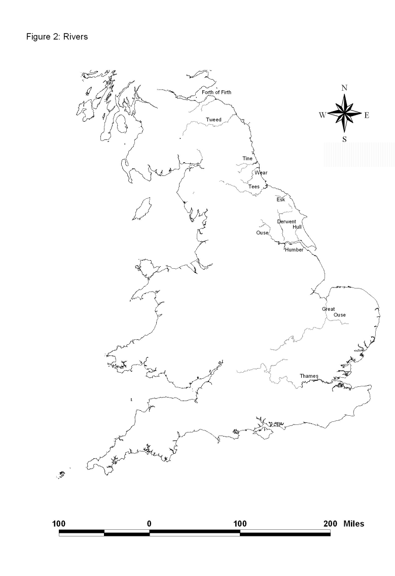
§6. Over the last decade archaeologists and historical geographers have made considerable advances in understanding the coastal regions and river systems of later medieval England. John Langdon (2000), Evan Jones (2000), and Jim Edwards and Paul Hindle (1991), whose debates were published in the Journal of Historical Geography, have done much to inform our understanding of the navigability of the various river systems in this period. While our understanding of the historic use of waterways in England during the later Middle Ages has advanced, there a number of factors which serve to limit our ability to accurately interpret the geography from the period under investigation, including the changing nature of these features over the centuries (Langdon 2000, 76). Fortunately, there are textual sources which contain references to sea and riverine voyages during the Early Medieval period. Bede's Life of Cuthbert contains many references to journeys by boat, including monks from Jarrow blown out to sea after returning from upriver (the Tyne) with raw timbers for construction (Life of Cuthbert, Ch. 3). Bede's Ecclesiastical History records numerous journeys as far as Rome, including those of St. Wilfrid (Bede Ecclesiastical History 3.13) and the West Saxon king Cadwalla's baptism there (Bede Ecclesiastical History 5.7). Many of the letters of Saint Boniface and the Life of Saint Wilfrid contain references to journeys by boat. From a wider perspective, the epic saga of Beowulf is rife with the myth and meaning of seafaring in the early medieval North Sea world (Alexander 1973). In addition to direct references to navigation, the textual sources often record the presence of Northumbrian palace sites along known rivers. Bede's Ecclesiastical History, for example, includes references to palace sites adjacent to the Rivers Nidd, Ouse, and Don. The Peterborough Manuscript of the Anglo-Saxon Chronicle notes the death of the Northumbrian king Aldfrith in AD 705 at Driffield, which lies near the head of the Hull River Beck (Anglo-Saxon Chronicle Ms. E, An. 705). The documentary sources, while offering intriguing potential for reconstructing maritime transport in the region, are tantalizingly vague and should be interpreted with caution.
§7. In general, textual evidence for the navigation of waterways in the south is better than that for the north, a dichotomy due in no small part to the peculiarities of data for the north, Yorkshire in particular, in the Domesday Book. Historians have long lamented the incomplete, duplicated, or sometimes curious entries for the region in the Domesday Book (Maxwell, 1962, 89). However, where the documents are vague, the archaeology has the potential to inform our understanding of human exploitation of the landscape. It is becoming apparent that the study of ceramic distributions will inform our understanding of the transportation of goods and therefore provide a valuable insight into the navigability of river systems (Mainman 1990, 466-69). Indeed, work on Anglo-Scandinavian pottery from the Coppergate excavations in York has highlighted the potential for archaeological investigation to deepen our understanding of Anglo-Saxon exploitation of the waterways of the region. Further, work of a statistical nature, like that carried out on Roman pottery by Fulford and Hodder (1975, 26-33), might further elucidate our understanding of navigable river systems in the north during the Anglo-Saxon period. In East Yorkshire the recent discovery of an early medieval logboat with a C14 date of AD350-560 (2 standard deviation-95% confidence limits) adjacent to a section of trackway made from woven wattles and wooden bars further demonstrates the survivability of organic material under the proper circumstances. The trackway, which led to a wharf on the River Foulness, yielded a C14 date of AD 530-690 (2 standard deviation-95% confidence limits) and likely connected the wharf to a nearby early medieval settlement at Bursea, about 2 km to the east (Ottaway 2004). The Foulnes played an important role as a transport route in the Iron Age and Romano-British phases in the area (Millett and Halkon 1988, 43) and, given the discovery of the logboat and wharf, there seems little doubt that this continued into the early medieval period as well. Rivers known to have been navigable for at least some distance include the Rivers Derwent, Humber, Hull, Ouse, Tyne, Tees, Wear, and possibly the Tweed.
§8. The constraints of the present format prevent a full-scale archaeological survey of the eastern coastline of England. Therefore, the following brief inquiry into the physical landscape focuses on the coastline of the northeast and should adequately serve the needs of this paper. The survey area begins in the north at the Forth of Firth and continues south to the Humber. In order to stay within the research framework set out in the opening of the paper, the historically known sites mentioned in Bede's Ecclesiastical History have been included.
§9. Beginning in the north and working southwards, the first potential harbor is near the Anglo-Saxon monastic center of Coldingham where Bede (Bede Ecclesiastical History 4.19) records King Egfrid of Northumbria's virgin wife Etheldreda serving under the Abbess Ebba. The monastic center of Coldingham lies a quarter of a mile west of the sea, where the shore offers little more than a stretch of open beach. While this would have been sufficient for the beaching of boats, it offers little or no protection from storms. However, there is a small harbor at nearby Saint Abbs, formerly known as Coldingham Shore, that offers some refuge to watercraft (Makepeace 1993, 24-25). Unfortunately, even here it would have been necessary to haul the boats up the shingly beach.
§10. Traveling southward along the coast, the area around the Northumbrian stronghold of Bamburgh offers the next safe harbor. Bamburgh is the site of what is believed to be the earliest stronghold of the Bernician elite in the region. The present castle is located on a rocky prominence which rises a considerable distance above the North Sea, providing a commanding view and a formidable defensive base on the coast (Stenton 1971, 74). The closest suitable harbor site to Bamburgh is Budle Bay, which is formed by the mouth of the River Warren (Makepeace 1993, 27-28). The castle stronghold itself is situated a little under three miles south, directly above an area of sandy beach that forms the second possible safe haven. While offering little protection from storms, the site would have been suitable for beaching Anglo-Saxon ships (Makepeace 1993, 29). A third area of safe harbor lies approximately four miles up the coast on the island of Lindisfarne or Holy Island. In addition to serving as the seat of the early Hiberno-Northumbrian church, Lindisfarne was also a very early Saxon period stronghold (Stenton 1971, 74-75). Due to its proximity to Bamburgh and the close association of the Bernician/Northumbrian kings with the monastery, it seems reasonable to assume that the harbor may have met the needs of the monastic community as well as the Northumbrian king (Makepeace 1993, 29-31). Indeed, the remoteness of the island, being only connected to the mainland by a natural causeway that is covered twice daily by the tide, would likely serve to further protect the nhabitants (Bede Ecclesiastical History 3.3).
§11. Continuing southward from Bamburgh the next harbor is at the twin monastic centers of Monkwearmouth and Jarrow (Makepeace 1993, 32-37). Monkwearmouth, founded c. 673, was the first of the two centers, with Jarrow following c. 681 (Cramp 1999, 325). The Venerable Bede, the Anglo-Saxon monk, theologian, and historian, was born on land owned by Monkwearmouth. As a young boy he entered the monastery that was to be his home for much of his life (Bede Ecclesiastical History 5.24). Despite the seemingly remote locations, Monkwearmouth and Jarrow were in no way isolated outposts in the Christian world. Indeed, in 676 John, abbot of Saint Martin's monastery and archicantor of Saint Peter's in Rome, made a visit (Cramp 1999, 325).
§12. Monkwearmouth is situated less than one-quarter mile upstream from the mouth of the river Wear and would have offered an excellent and safe harbor for ships of Saxon design. The monastic center at Jarrow is located along the banks of the River Don, one of the river Wear's tributaries, some three miles upstream from the mouth of the Wear. While Jarrow was perhaps not as convenient as the harbor at Monkwearmouth, it was at least possible to travel there by boat at times of high tide when the Don was likely navigable using a shallow draught boat (Makepeace 1993, 32-37).
§13. Continuing southward, the next safe harbor is near the monastic center at Hartlepool (Makepeace 1993, 37-41). Judging from its role as the burial ground for the Northumbrian elite, Hartlepool must have been an important Northumbrian center from its foundation c. 640 (Daniels 1988; Sherley-Price 1990, 184). Indeed, Bede tells us that Oswiu of Northumbria placed his daughter Aelfflæd under the respected abbess Hild at Hartlepool in thanks for his victory at the Battle of Winwaed in 655 (Bede Ecclesiastical History 3.24). Based on the archaeological evidence and historical sources it seems certain that Hartlepool was an important royal, as well as ecclesiastical, center. Indeed, if the pattern of Northumbrian monastic centers associated with natural harbors so far observed reflects a real pattern, then the presence just to the east of Hartlepool of an excellent natural harbor argues in favor of this. The harbor at Hartlepool is situated to offer shelter from all wind directions except due south. This however, posed little danger as the force of southerly winds is usually moderate in this region (Makepeace 1993, 39). However, the harbor at Hartlepool is not alone in the area. The river Tees is only four miles to the south, and it too could have provided ample shelter for shallow-draft Anglo-Saxon craft.
§14. Continuing southwards, there is a possible site of safe haven near Lythe, where a small sandy beach of the kind perfectly suited to the beaching of early medieval watercraft, forms an inlet to the interior of the North Yorkshire Moors. Archaeological evidence is scant, but there is an above-average incidence of Anglo-Scandinavian sculpture that has survived in the fabric of the present St. Oswald's church at Lythe (Lang 2001). While there are no written sources attesting to an ecclesiastical center at the site, the archaeological evidence suggests that at least from the Anglo-Scandinavian period, c. 850, the site was important. While in and of itself this is insufficient evidence, the deposition of sculpture in similar quantities conforms to Stocker's (2000) observations on the sculpture deposition pattern near Anglo-Scandinavian market centers in Lincolnshire and the East Riding of Yorkshire.
§15. Further south, the next likely safe harbor is near the monastic center at Whitby, which was founded on land granted by King Oswiu as one of the twelve monastic centers created after his victory over Penda of Mercia (Bede Ecclesiastical History 3.24). The ruins of the twelfth-century monastery sit on top of the Anglo-Saxon monastic center that was destroyed in the Viking raids of the ninth century (Radford and Peers 1943). The monastic center is situated on a prominent headland overlooking the river Esk. While it may not have been navigable for any great distance at low tide, at high tide the Esk could have provided shelter for the shallow draught boats favored by the Anglo-Saxons. In addition, approximately 300 yards from the monastic center is a sandy beach upon which it would have been possible to beach Anglo-Saxon craft. Beyond Whitby only the Humber and its numerous tributaries provide shelter (Makepeace 1993, 41). To summarize, the inquiry has identified six potential areas of safe harbor along the coastline of Northumbria. These are at Coldingham; the area around the Northumbrian stronghold of Bamburgh, which includes three areas of safe harbor; as well as the monastic centers at Monkwearmouth and Jarrow, Hartlepool, Lythe, and Whitby.
The Technological Landscape: Anglo-Saxon Maritime Technology—Did They or Didn't They?
§16. Anglo-Saxon maritime technology has been the subject of much recent academic debate.2 Due to the number of articles and essays on the subject, this paper will not attempt to restate the arguments so eloquently put forward elsewhere. Rather it will focus on technical aspects of Anglo-Saxon ship technology that relate to the navigability of certain waterways. This aspect of the debate is relevant precisely because our ability to interpret political communities during the sixth and seventh centuries is to a great extent dependant on our ability to understand the ways in which the various actors in those communities interacted and communicated with one another. Within this context, two questions are paramount. First, did the Anglo-Saxons posses sail technology? Second, how did the design of the crafts affect their performance in coastal and riverine environments?
§17. We know from history that the Saxons were accomplished seamen (Haywood 1994). Indeed, from as far back as the late fifth century, the Saxons were feared for their maritime prowess. In a letter dated c. AD 473, Sidonius Apollinarius writes that the Saxons were "ready to unfurl their sails for the voyage home from the continent and to lift up their gripping anchors from enemy waters". A further literary reference to Anglo-Saxon sailing capability comes in the form of a description (c. AD 721) of the Anglo-Saxon missionary Saint Willibald setting sail from Hamblemouth. The vessel is described as a "swift-sailing ship" with "full sails."
§18. Where the documentary sources are plentiful, the archaeological evidence is at present scant. To date no early Anglo-Saxon vessel has been excavated that has provided evidence for its construction beyond the hull. Unfortunately this has left a great deal of uncertainty over the design of any actual sailing mechanism. Possible reasons for this include aspects of the recovery and survival of Anglo-Saxon boats. First, boats that were lost at sea, where we should expect to find sails and fittings in situ, are unlikely to be recovered for obvious reasons. Second, given the expense in both man-hours and materials associated with the felling, transport, splitting, and shaping of the timber planks, any vessel that may have sank in a riverine or harbor environment—exactly the locations we would be likely to find them—would have been salvaged if at all possible. Additionally, given the same criteria, any salvageable material from a vessel beyond its useful lifespan would have been reused in other contexts and therefore may be un-recognizable, even if it were found in a sufficiently preserved state. However, there are cases where re-used material from ships has been recovered archaeologically. The discovery of significant quantities of salvaged ship material in the embankment revetments from along the river Thames near London demonstrates that the material can survive in a recognizable form given the right conditions (Goodburn 1994). The Welham boat discussed earlier demonstrates the survivability of organic material in wetland areas (Ottaway 2004).
§19. Be that as it may, the work of experimental archaeologists has provided a great deal of information on the design, construction, and sailing characteristics of Anglo-Saxon ships. Indeed, Gifford and Gifford (1996) argue that the hull design of the Sutton Hoo ship is of a type normally associated with sail power. The Giffords (1996, 132) note that in both the Graveney boat and the Sutton Hoo ship:
the mid-ship section has a markedly flat bottom with round bilges, which is good for carrying sail and for speed, and is not commonly associated with a galley or barge . . . . [T]he plan form is leaf-shaped such as is generally associated with sailing vessels, as distinct from the near parallel sides of a rowing galley.
That is not to say that Anglo-Saxon ships were not capable of being powered under oar. Indeed, the Sutton Hoo ship demonstrates this point (see Evans 1986; Carver 1998). Therefore, in deference to the two possible modes of propulsion, this paper will use calculations for both oar and sail power in its examinations of the political communities that formed along the eastern coast of England in the Early Middle Ages.
Travel Time
§20. It has often been remarked upon that when one looks at the topography of early medieval England, the Anglo-Saxons appear to have displayed a preference for founding their important centers near the coast and along navigable river systems (Gifford and Gifford 1999, 86). Carver (1988) has suggested that to interpret the geopolitical situation of the communities along the northeast coastline of Britain, historians and archaeologists must flip their political maps inside out so that the North Sea costal zone is viewed as a common border rather than as a barrier to be overcome:
It is not a terrestrial zone but a maritime one, in which the eastern coastline of Britain plays the role of an arterial route, bringing all the estuaries of the east, in theory at least, nearer to each other than to their contiguous western land mass (Carver 1990, 39).
§21. Suppose that a person living during the early medieval period in England wished to travel from Bamburgh to the monastic center at Bradwell-on-Sea. Three modes of travel were available to them: they must walk, ride an animal, or travel by boat. What impact does the mode of travel chosen have on our interpretation of the developing political communities in sixth- and seventh-century northern England? How might the realities of travel and transportation technology effect the political development of early medieval communities in and around the North Sea coast of England?
§22. In order to address these questions it is necessary to conduct a comparison of the time-space disparity—a rather long winded term intended to denote time traveled in comparison to distance covered—that exists between the three basic modes of travel. The following considerations have been included in the calculations for travel times and distances. First, where land routes are calculated the shortest route along known Roman roads and medieval trackways has been used. To calculate overland travel times, the pace of 15 miles per day is used. This rate represents a compromise between walking or riding along good roads and trackways, and along poorly maintained or defined seasonal routes. Second, in the calculations for travel via inland waterways, only those river systems that are known to have been navigable in the early medieval period, essentially the Thames, Humber, Ouse, Tees, and Wear, are used. Lastly, the rate of travel for sailing was taken as 81 miles per day and that for rowing has been calculated at a rate of 41 miles per day.3 The figures for overland, oar, and sail rates cited above are conservative to a degree. Indeed, the data generated from their half-scale model of the Sutton Hoo ship, Gifford and Gifford (1996, 152) suggests that a voyage from York to Canterbury in the full-sized ship, a journey of c. 300 miles, would have taken only two days.
§23. Figure 3 shows the travel times from the Northumbrian stronghold of Bamburgh to the various locales discussed earlier, graphed according to the mode of travel. Travel times to the various destinations are markedly different across the three modes of transport. Indeed, the disparity is even more dramatic when it is plotted on a graph. Figure 4 illustrates the differences. The Northumbrian stronghold of Bamburgh is represented by No. 1 (all numbers on the graph reflect the numbers assigned to each location in the table Fig. 3), and travel times in days from Bamburgh graphed.
Figure 3
| Chart and Graph No. | Location | Overland Distance in Miles | Sea Distance in Miles | Travel Time by Land in Days | Travel Time by Oar Power in Days | Travel Time by Sail Power in Days |
| 1 | Bamburgh | |||||
| 2 | Abercorn | 80 | 70 | 4.66 | 1.7 | 1.0 |
| 3 | Coldingham | 14 | 20 | 1.0 | 0.5 | 0.25 |
| 4 | Wearmouth/Jarrow | 80 | 55 | 5.3 | 1.3 | 0.67 |
| 5 | Hartlepool | 95 | 75 | 6.3 | 1.8 | 0.91 |
| 6 | Whitby* | 180 | 100 | 12.0 | 2.4 | 1.21 |
| 7 | York | 135 | 235 | 9.0 | 5.7 | 3.0 |
| 8 | Ripon** | 162 | 262 | 10.8 | 6.7 | 4.0 |
| 9 | Goodmanham | 165 | 205 | 11.0 | 5.0 | 2.5 |
| 10 | Bradwell-On-sea | 380 | 360 | 25.3 | 8.7 | 4.3 |
| 11 | Tilbury | 330 | 375 | 22.0 | 9.1 | 4.5 |
| 12 | Kent | 340 | 395 | 22.6 | 9.6 | 4.8 |
| 13 | East Saxons | 360 | 360 | 24.0 | 8.7 | 4.3 |
*Travel time from Bamburgh to Whitby is via the Roman Road south and then northeast via known Roman roads. It is acknowledged that an early medieval track-way may have run from the Roman road to Whitby via a route that skirted the northern edge of the moors. This route would have been significantly shorter but evidence for its existence requires a combination of overland and water routes to reach it and the travel time suggested reflects this.
Figure 4
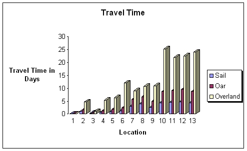
§24. Using the travel times from Bamburgh to the kingdom of the East Saxons, which is roughly the same for overland and sea routes, travel times overland are generally 62 percent longer than oar power and 82 percent longer than sail. When travel times for waterborne travel powered by oar is calculated, the furthest point from Bamburgh is the kingdom of Kent at 9.6 days. Indeed, 70 percent of the sites listed in Figure 3 are less than seven days travel time from Bamburgh. Abercorn, Coldingham, Wearmouth and Jarrow, Hartlepool, and Whitby are all within four days travel from Bamburgh, while Goodmanham, York, and Ripon are between 5 and 6.7 days away.
§25. The effect of oar-powered waterborne transport on the time-space differentiation within Northumbria is dramatic. When the rates of sail-powered travel data are, however, plotted on the graph, the implications for the relationship between Northumbria and its Anglo-Saxon allies along the eastern coast of Britain are significant. When traveling from Bamburgh under sail, landfall in the kingdom of Kent could be achieved in a mere 4.8 days. Indeed, the journey between Bamburgh and Bradwell-on-sea is reduced from more than 25 days to less than 4.3. The effect of travel times by sail power from Bamburgh to centers along the water routes to Bradwell-on-Sea and Tilbury confirm that rather than peripheral centers, at 4.5 days travel time, they are as easily accessible as sites in the interior of Northumbria. Certainly the travel time to these southern centers is comparable to those for overland journeys to York and Ripon. Given the results of these limited studies, it seems reasonable to suggest that when the geopolitical map of Northumbria is reversed (see Carver 1990) and the sea interpreted as a common border—or rather a transportation route—and not as an obstacle, the landscape of Northumbria alters markedly.
Some Conclusions
§26. This paper has attempted to highlight the potential of an interdisciplinary approach to address some of the outstanding questions of the political, technological and geographical realities of the Anglo-Saxon world. Where the documents can inform us of events and alliances, the archaeology and historical geography offer a greater understanding of the resources available to elites, as well as how they used them. Indeed, further research in the distribution of pottery and imported goods among coastal communities and along river systems has the potential to greatly increase our understanding of the political communities that were developing during the sixth and seventh centuries in Anglo-Saxon England.
§27. The historical sources tell us that during much of the early medieval period the Northumbrian kings were locked in a struggle with their Mercian rivals for regional supremacy. This competition likely had an impact on the preferred modes of travel for many in the Northumbrian elite. While the Northumbrians documentary sources tell us that they often used the network of Roman roads, this may not have been the safest option if one wished for "peaceful" long-distance travel. Further, the results of the analysis of travel times in this paper have demonstrated that water routes were certainly more efficient than overland. Indeed, this was always so, from antiquity through the nineteenth century. Green's (1986) calculation of the cost of transporting goods in the Roman Empire in comparison to the cost in the nineteenth century demonstrates this. Green calculated that the cost for transport of goods by land, river, and sea was 1: 4.9: 28 during the Roman Empire and 1: 4.7: 22.6 in the nineteenth century (Green 1986).
§28. It is suggested that far from acting as a barrier to travel, the river systems and coastal resources of the northeast offered an attractive option to overland routes both in terms of cost efficiency and safety. It was also argued that on balance of the documentary and archaeological evidence, Anglo-Saxon maritime technology and navigational skill was sufficient to allow the Northumbrian political elite to exploit the natural advantages offered by the water routes whether by sail or by oar. This paper has attempted to combine data from three distinct disciplines—archaeology, history, and historical geology—in an effort to reconstruct the physical realities confronting political leaders of sixth to eighth century in Northumbria, and to assess the ways in which the political communities of the region adapted to their environment. It was argued that the Northumbrians pursued the advantages offered by their geography and formed political alliances with other regional polities distributed along the southern and south-eastern coast of England. Indeed, far from occupying a distant place, the time/distance comparisons presented demonstrated that that while many of these allies were geographically distant, the relative speed of travel via the water routes brought them closer in many cases to Bamburgh than to some sites in the interior of Northumbria.
Notes
1. Lynch (1998) asserts that every baptism in medieval Europe had the potential to create a familial relationship referred to by theologians as "spiritual kinship." The baptismal sponsor was key to this new relationship. [Back]
2. For further reading please see Goodburn 1986; McGrail 1987; Christiansen 1992; and Carver 1990. [Back]
3. These figures have been adapted from Carver (1988). [Back]
References
Abels, Richard. 1983. The Council of Whitby: A study in early Anglo-Saxon politics. The Journal of British Studies 23:1-25. [Back]
Alexander, Michael, trans. 1973. Beowulf: A verse translation. New York: Penguin Books. [Back]
Bede. 1990. Ecclesiastical history of the English people. Ed. Leo Sherley-Price. London: Penguin. [Back]
Carver, Martin. 1990. Maritime Celts, Frisians, and Saxons: Papers presented to a conference at Oxford in November 1988. Ed. Sean McGrail. London: Council for British Archaeology. [Back]
———. 1998. Sutton Hoo: Burial ground of kings? London: British Museum Press. [Back]
Colgrave. B., ed. 1940. Two Lives of St. Cuthbert. Cambridge: Cambridge University Press.
Christiansen, Arne-Emil. 1992. Medieval shipping in the North Sea. Paper presented at the Maritime Studies, ports and ships. University of York.
Cramp, Rosemary. 1999. Monkwearmouth (or Wearmouth and Jarrow). In The Blackwell Encyclopedia of Anglo-Saxon England, eds. John Blair et al. Oxford: Blackwell Publishers Ltd. [Back]
Daniels, Robin. 1988. The Anglo-Saxon monastery at Church Close, Hartlepool, Cleveland. The Archaeological Journal 145:158-210. [Back]
Edwards, Jim and Paul Hindle. 1991. The transportation system in medieval England and Wales. Journal of Historical Geography 17:123-134. [Back]
Evans, A. 1986. The Sutton Hoo ship burial. London: British Museum Press. [Back]
Fulford, M. and I. Hodder. 1975. A regression analysis of some late Romano-British pottery: A case study. Oxoniensia 39: 26-33. [Back]
Gifford, Edwin and Joyce Gifford. 1996 The sailing characteristics of Anglo-Saxon ships as derived from half-scale working models with special reference to the Sutton Hoo ship. International Journal of Nautical Archaeology 24:131-153. [Back]
Gifford, Edwin and Joyce Gifford. 1999. The art of Anglo-Saxon shipbuilding. In Northumbria's golden age, eds. Jane Hawkes and Susan Mills. Thrupp, Stroud, Gloucestershire: Sutton Publishing. [Back]
Goodburn, D. 1986. Do we have evidence of a continuing Saxon boat-building tradition? International Journal of Nautical Archaeology 15:39-47.
Goodburn, D. M. 1994. Anglo-Saxon boat finds from London, are they English? In Cross Roads in Ancient Ship Building, 23-76. Oxbow Monograph 40. [Back]
Green, Kevin. 1986. The archaeology of the Roman economy. London: B.T. Batsford Ltd. [Back]
Haywood, John. 1994. Dark age naval power. Routledge. [Back]
Higham, Nicholas. 1993. The kingdom of Northumbria: AD 350-1100. Thrupp, Stroud, Gloucester: Alan Sutton. [Back]
———. 1997. The convert kings. Manchester: Manchester University Press. [Back]
Jones, Evan T. 2000. River navigation in medieval England. Journal of Historical Geography 26:60-75. [Back]
Lang, James. 2001. Corpus of Anglo-Saxon sculpture. Vol 6, Northern Yorkshire. Oxford: Oxford University Press. [Back]
Langdon, John. 2000. Inland water transport in medieval England—the view from the mills: A response to Jones. Journal of Historical Geography 26:75-82. [Back]
Lynch, Joseph H. 1998. Christianizing kingship: Ritual sponsorship in Anglo-Saxon England. Ithaca, New York: Cornell University Press. [Back]
Mainman, A. J. 1990. Anglo-Scandinavian pottery from 16-22 Coppergate. York: York Archaeological Trust for Excavation and Research. [Back]
Makepeace, John. 1993. Early medieval harbours in Northumbria. MA thesis, University of York. [Back]
Maxwell, I. S. 1962. Yorkshire: The North Riding. In Domesday Geography of Northern England, eds. H.C. Darby and I.S. Maxwell. Cambridge: Cambridge University Press. [Back]
McGrail, Sean. 1987. Ancient boats in NW Europe. The archaeology of water transport to AD 1500. London: Longman.
Millett, Martin and Peter Halkon. 1988. Landscape and economy: Recent fieldwork and excavation around Holme-on-Spalding Moor. In Recent research in Roman Yorkshire: Studies in honour of Mary Kitson Clark (Mrs Derwas Chitty), eds. J. Price and P. R. Wilson with C. S. Briggs and S. J. Hardman. BAR British Series No. 193. Oxford: British Archaeological Reports. [Back]
Ottaway, Patrick. 2004. Welham Bridge Boat. [Website] At York Archaeological Trust. York: York Archaeological Trust. Available at http://www.yorkarchaeology.co.uk/welham.htm. [Back]
Radford, C.A.R. and C.R. Peers. 1943. The Saxon monastery of Whitby. Archaeologia 99:27-88. [Back]
Stenton, Frank. 1971. Anglo-Saxon England. 3d ed. Oxford: Oxford University Press. [Back]
Swanton, M. J., trans and ed. 1996. The Anglo-Saxon chronicle. London: Dent. [Back]
Stocker, David. 2000. Monuments and merchants: Irregularities in the distribution of stone sculpture in Lincolnshire and Yorkshire in the tenth century. In Cultures in contact: Scandinavian settlement in England in the 9th and 10th Centuries, eds. D.M. Hadley and J. D. Richards. Belguim: Tumhout. [Back]
Ziegler, Michelle. 2002. Eanflæd's bridal voyage. Paper presented at the 37th International Congress on Medieval Studies, Kalamazoo, Michigan. [Back]